GeoCable® Data & Software
Over 2.8 million km of submarine cable data at your fingertips
A revolutionary submarine cable data set unrivalled elsewhere within the industry, affording you quick access to vast quantities of submarine cable data
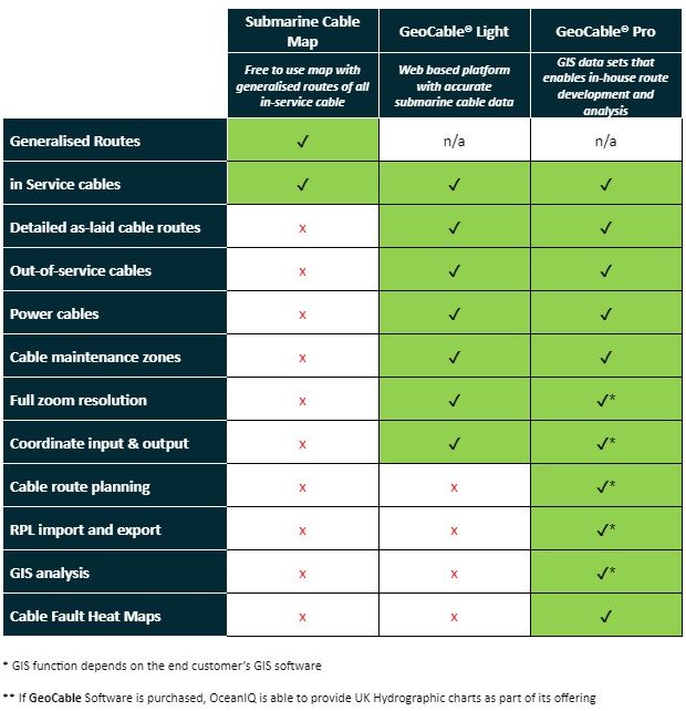
Get a Quote!OceanIQ prides itself on its extraordinary set of subsea cable data that it has managed and updated over many decades. The team has recently expanded the product range to accommodate increasing interest for wider business consumption outside of the traditional GIS teams. A range of products that cater for a broad spectrum of customers, developed by the team, now enable entire organisations to have access to this highly important data. The GeoCable data set is available through our free submarine cable map, or via GeoCable®Light or GeoCable®Pro subscription services.
Here is an easy guide outlining what is available through each service, so you can decide which service best suits your business requirements.

Detailed knowlegde of 97% of all fibre & 70% of power cables

World-leading GeoCable® GIS database, comprising over 2.6 million kilometers of cable

Access to over 6,000 historical cable faults, approximately 95% of all faults worldwide

Wealth of global experience and records management for over 150,000km of in-service cable systems
Access accurately mapped submarine cable routes
Gain layers of cable route information
GeoCable® GIS Data provides you with multiple types of cable data such as in-service and out-of-service fibre optic, out of service coaxial, telegraph and power cables.
Cable route information that has been compiled from numerous sources by Global Marine Group, during the course of its marine operations spanning the last 170 years. Recognised by installers, cable owners and governments as the de facto data set.

Bespoke cable data, no matter the scenario