Contact Us
Wednesday 12th July 2023 | Blog written by Neil McLauchlan, Route Engineer
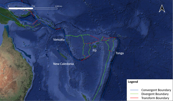
Boundary zones are relatively new terminology that describes the movement of two major plates with several microplates between them. Microplates are smaller fragments of lithosphere with their own defining, yet complicated, boundary. The boundary zone usually covers a broad area, which can be over 1000km wide, and includes two plate types (divergent, convergent or transform) or even all three in places. Therefore, marine boundary zones act as a focal point of hazards when completing cable route enginerring, such as: volcanoes; earthquakes; tsunamis; landslides; hydrothermal vents; liquefaction; and fissures, to name a few.
The boundary zone that encompasses Tonga, Fiji and Vanuatu is an example that includes convergent, divergent and transform boundaries and shows signs of rotation. This is akin to the transpressional restraining bend, discussed previously in the transform boundaries blog, but on a larger scale.
The region was in the news in 2022 due to the eruption of a volcano, that was mainly underwater. The Hunga Tonga-Hunga Ha’apai volcano eruption sent ejecta not only into Earth’s stratosphere, but also into the mesosphere. The plume reached almost 58km high and ejected more water vapour than the 1991 Mount Pinatubo eruption. Sonic booms created by the eruption were heard in New Zealand and Australia. The eruption displaced almost 10km3 of material as the caldera collapsed, falling by approximately 700m, causing a tsunami. Although the tsunami didn’t affect any communication cables directly, the pyroclastic flow reached a distance over 80km away from the eruption, severing the communication cable landing in Tonga. The communication cable was located approximately 50km south of Tonga behind several topographical highs. The force of the eruption reshaped the topography of the seafloor, levelling some areas and flowing over others. Demonstrating that even when hazards are mitigated, cables are still vulnerable to unexpected or rare hazards over their lifecycle but through cable route engineering impacts can be minimised.
References:
Amos, J., 2022. Tonga volcanic eruption reshaped Pacific seafloor. British Broadcasting Corporation. Available at: https://www.bbc.co.uk/news/science-environment-63678177
BBC, 2022. Tonga tsunami: Communications ‘may be down for two weeks’. British Broadcasting Corporation. Available at: https://www.bbc.co.uk/news/world-asia-60021759
Cuff, M., 2022. Tonga eruption’s volcanic plume reached above the stratosphere twice. New Scientist. Issue 3412. Available at: https://www.newscientist.com/article/2345643-tonga-eruptions-volcanic-plume-reached-above-the-stratosphere-twice/
NASA, 2022. Tonga Eruption Blasted Unprecedented Amount of Water Into Stratosphere. NASA Jet Propulsion Laboratory. Available at: https://www.jpl.nasa.gov/news/tonga-eruption-blasted-unprecedented-amount-of-water-into-stratosphere
NOAA, 2022. NOAA helps fill critical communication gaps in wake of Tonga Tsunami. National Oceanic and Atmospheric Administration. Available at: https://www.noaa.gov/stories/noaa-helps-fill-critical-communication-gaps-in-wake-of-tonga-tsunami
Proud, S. R., et al., 2022. The January 2022 eruption of Hunga Tonga-Hunga Ha’apai volcano reached the mesosphere. Science. Vol 378 (6619). pp554-557. Available at: https://www.science.org/doi/10.1126/science.abo4076 USGS, 2022. [Database] Plate Boundaries. Available at: https://earthquake.usgs.gov/learn/plate-boundaries.kmz
 Author: Neil McLauchlan, Route Engineer
 Neil is one of OceanIQ’s experienced Route Engineers