Contact Us
Monday 4th December 2023 | Blog written by Brian Perratt, OIQ Permitting & GIS Manager
Celebrating 25 years of exceptional data insight.
The evolution of the submarine cable industry during this timeframe.
For 25 years GeoCable® has been at the forefront of subsea cable mapping, monitoring, and logging subsea cable installation and faults. GeoCable’s subsea cable map of up to date and historical data helps operators plan new cable installations, support repair operations, anticipate potential issues, and improve the overall reliability of a subsea cable system. This valuable resource is indispensable for various stakeholders operating across diverse marine industries, including renewable energy, power, telecoms and survey.
Fibre optic cables continue to play a critical role in global telecommunications, enabling high-speed data transfer and international connectivity. The ongoing expansion and development of subsea cable systems is predicted to continue as the demand for connectivity and data transfer capabilities increases.
Over the last 25 years we have seen a remarkable evolution in subsea fibre optic cables and subsea cable maps.
Advances in technology have significantly increased the capacity of subsea cables. The adoption of wavelength division multiplexing (WDM) and coherent optical technology has allowed for multiple channels of data to be transmitted simultaneously over a single fibre pair, greatly boosting overall capacity. The development of higher-capacity and higher-speed cables has allowed for faster data transmission rates. This is essential for supporting the growing demand for bandwidth-intensive applications, including video streaming, cloud services, and virtual reality.
With the increasing importance of real-time applications, such as online gaming and financial transactions, there has been a growing emphasis on reducing latency in subsea cable systems. New cables are designed to minimize signal propagation delays.
Even with the advances in technology allowing for ever greater bandwidths in a single cable system this is still not enough to service the insatiable appetite for more and more bandwidth. The number of cables on the seabed has had to increase substantially in the last 25 years to ensure these bandwidth needs are met.
New cables have been deployed to connect continents and regions, enhancing communication and data transfer capabilities. Traditional transatlantic and transpacific routes, have gained additional new cable systems as well as previously underserved or unconnected regions, improving global network redundancy and resilience.

Prediction for cable growth 2023 -2027.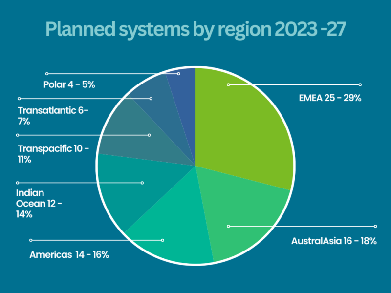 Source: SUBMARINE TELECOMS INDUSTRY REPORT 2023 | 2024
Stakeholder diversity – Initially, many subsea cables were owned and operated by telecommunications companies. The increasing demand for data transfer capacity has led to increased investment in subsea cable projects. Governments, private companies, and consortia are investing in the development of new cables to meet the growing global demand for connectivity. Over, the last 25 years, technology companies, consortiums, and private investors have also become key players in the development and ownership of subsea cable systems.
Environmental concerns have become more prominent in recent years. Cable operators are taking measures to minimize the impact of cable installation on marine ecosystems, and there is a focus on developing more environmentally friendly cable materials and deployment methods.
Security Concerns and the importance of securing subsea cables against physical and cyber threats has become a priority. Governments and private entities are increasingly aware of the strategic importance of these cables and the need to protect them from potential disruptions.
Subsea cable faults can result from a variety of factors, ranging from natural phenomena such as seismic activity and adverse weather conditions to human activities such as fishing and anchoring. Efforts to prevent and mitigate these faults involve a combination of careful route planning, improved cable installation techniques, ongoing monitoring, and timely repair operations in the event of a fault.
The Evolution of GeoCable®
OceanIQ has been actively engaged in the installation and upkeep of subsea cables since the inception of the industry in 1850. Over the last 25 years, our specialized team of GIS experts have meticulously curated GeoCable’s exceptional and distinctive dataset – an incredibly accurate subsea cable map. Continuous logging of data related to new and existing cable routes and performance as well as environmental conditions is crucial for post-event analysis and ongoing maintenance. This wealth of historical data is constantly enriched and updated and serves as crucial intelligence for cable owners, installers and maintainers, offering precise details on the extensive 2.8 million km of subsea cables currently on the seabed.
Geocable continues to be an essential tool ensuring the security and integrity of this extensive submarine cable network.
Our Cable Fault Projection Reports leverage our comprehensive database of over 6,500 global cable faults, to produce a report tailored to a specific RPL. This report can identify probable causes and estimate the potential number of faults for a forthcoming cable system The report anonymises historical faults ensuring existing cables are not identified within the analysis providing a valuable tool for the industry in understanding past, present and future fault trends.
OceanIQ takes pride in GeoCable’s unparalleled collection of subsea cable data, a subsea cable map and intelligence which has been carefully maintained and updated over several decades. Recently, the team has broadened the GeoCable® product offerings to meet growing interest from a wider business audience beyond traditional GIS teams. The evolved GeoCable® dataset is now accessible through our complimentary submarine cable map, or via subscription services such as GeoCable®Light or GeoCable®Pro – providing different service levels to meet the needs of all users. For more information about these product offerings click here.
 Author: Brian Perratt
 With over 25 years of experience in the industry, overseeing all aspects of Permitting, Charting, SEA Data records management and GIS, OIQ Permitting & GIS Manager – Brian Perratt has gained a wealth of knowledge working on numerous marine projects around the world.